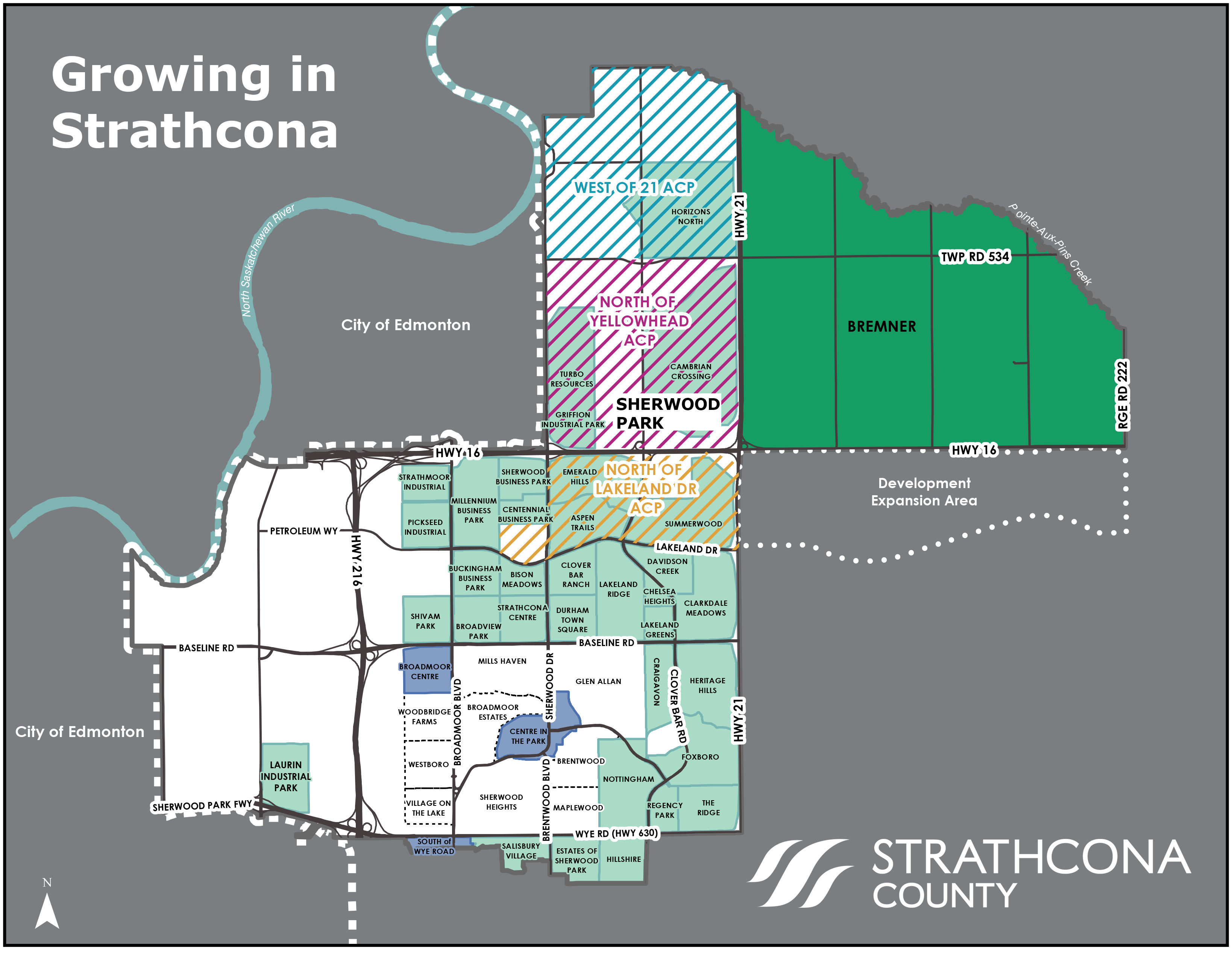
The Local Employment Area (LEA) is located across from Bremner, on the south side of Highway 16 spanning from Highway 21 to Range Road 222. The LEA encompasses approximately an area of 970 hectares of land and is intended for industrial and business employment.
The Local Employment Area (LEA) offers:
- Opportunities for light and medium industrial development
- Natural habitat conservation such as wetland and uplands
- Safe, reliable and efficient roads
Plans, maps and bylaws
No Area Structure Plan has been adopted yet for the LEA Area. Area landowners and developers can submit Sub-Area Structure Plans in accordance with the Bremner and LEA Area Concept Plan.
Bremner and LEA Area Concept Plan (ACP)
(23.3 MB)
Adopted by Council on September 10, 2019.

Common questions:
-
An Area Structure Plan (ASP) is a statutory (legal) plan that establishes rules for future growth in an area. It outlines how a specific community or neighbourhood can be developed.
-
Area Concept Plans are a general future land use concept that guides subsequent development plans, such as a local ASP.
-
What is the Municipal Development Plan (MDP)?
3. What is the Municipal Development Plan (MDP)?
Permanent link to What is the Municipal Development Plan (MDP)?The Municipal Development Plan is the long-term policy document that guides development over the next 20 years.
Learn more about the documents used in the planning process, and their hierarchy.
-
When was the Bremner and LEA Area Concept Plan adopted?
1. When was the Bremner and LEA Area Concept Plan adopted?
Permanent link to When was the Bremner and LEA Area Concept Plan adopted?On Tuesday, September 10, 2019, Council voted to adopt the Bremner and Local Employment Area ACP (Area Concept Plan).
-
When is the infrastructure needed to be constructed to service Bremner?
2. When is the infrastructure needed to be constructed to service Bremner?
Permanent link to When is the infrastructure needed to be constructed to service Bremner?There is a lot of infrastructure required for a new development like Bremner - things like roads, water mains, sewer lines and fire halls. Bremner is being planned as a sustainable community and the infrastructure plan is a big part of that. Some infrastructure, like roads, must be built before people can move to a neighbourhood. Other infrastructure, like recreation centres, can wait until there are enough people there to need it. Sherwood Park has been building-out over the past 65 years and has evolved from a single neighbourhood in the 1950's to what it is today. Decisions were not made day one, but over time based on the needs of the community as we grew. Similarly, it could take over half a century for Bremner and the Local Employment Area (LEA) to reach full build-out, with future infrastructure and development requiring consideration and approval by future Strathcona County Councils.
-
How is the infrastructure going to be funded?
3. How is the infrastructure going to be funded?
Permanent link to How is the infrastructure going to be funded?Regional infrastructure, such as interchanges, will be a shared cost between provincial and federal governments as well as developers. Historically, interchanges have been paid for by provincial and federal governments. On-site infrastructure, such as local roads, water and wastewater servicing will be constructed at the cost of developers, which is standard practice. The County will pay for infrastructure such as fire halls, reservoirs, recreation centres and operations facilities, in line with our current practice. County funded infrastructure is paid for through taxes, grants, utilities fees, operational revenue and user fees.
Approval of the Area Concept Plan does not result in Council approving funds on future infrastructure development for the area. Decisions on potential costs for future infrastructure and development will require consideration and approval by future Strathcona County Councils.
-
What is happening to current Bremner residents?
4. What is happening to current Bremner residents?
Permanent link to What is happening to current Bremner residents?Development is driven by landowners and developers - following the approval of area structure plans. Current and future residents will have a say in the future of their land. No current residents are required to sell their land.
-
What types of land uses are planned for Bremner?
5. What types of land uses are planned for Bremner?
Permanent link to What types of land uses are planned for Bremner?Bremner is intended to be built as a complete community with a variety of housing opportunities, shopping, institutional uses and employment.
-
What is the Local Employment Area (Development Expansion Area)?
6. What is the Local Employment Area (Development Expansion Area)?
Permanent link to What is the Local Employment Area (Development Expansion Area)?The Local Employment Area (Development Expansion Area) is located across from Bremner on the south side of highway 16, and is being planned for as part of the Bremner Area Project.
The area is anticipated to accommodate required infrastructure, interchanges and flyovers across highway 16. This area was previously identified for future light and medium industrial development. -
There is no set timeline for development to begin. The timing of development will depend on the market and pace of remaining development in Sherwood Park, and development in Cambrian Crossing (to the west of Bremner).
Before any development can occur, developers must submit Sub-Area Structure Plans to the County for Council approval.
Council adopted the Bremner Community 1 Sub-Area Structure Plan and the Bremner Community 4 Sub - Area Structure Plan in July 2021. both Sub-Area Structure Plans can be found here:
-
What type of land uses are planned for the Local Employment Area?
8. What type of land uses are planned for the Local Employment Area?
Permanent link to What type of land uses are planned for the Local Employment Area?The LEA is intended for industrial and business employment, with opportunities for light and medium industrial development.
Land Development Planning
Phone: 780-464-8080
Email: Community.Planning@strathcona.ca
Related topics
Last updated: Thursday, January 19, 2023
Page ID: 51337